News
E McMullan Ltd Now Providing UAV Surveys
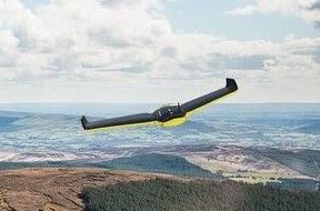
E McMullan Ltd now operate a Sensefly eBee UAV to enhance our growing range of surveying techniques. The Sensefly eBee is a fully integrated system which produces GIS ready data fit to be used with a wide range of geospatial programs. Sites which have proven difficult or dangerous to access can now be accurately, safely and rapidly surveyed using the UAV.
UAV surveys gather a much wider range of information in one flight than is obtained from a standard ground survey and can be provided in a range of formats further reducing time required to gather necessary data.
We have been granted permission from the CAA to carry out aerial work and are fully insured to conduct UAV surveys. Two fully BNUC-S trained pilots within the company perform professional aerial surveys safely and legally.